Descending the rock slabs on Mt. Stanley is just a slow process.
90% of my time anymore seems like I am driving to some worksite. Long drive, usually not too long a job. When I was climbing all the time, a slower pace was second nature. I am too used to a faster pace. It took a conscious effort to accept reality. For here, in the Ruwenzori, walking is the speed. These guys have all ridden in cars. I would think they will occasionally rent one. But, down, down, down, ever so slowly, is a challenge to my 'making peace with it' department.
Just keep in mind, "And, this too, shall end."
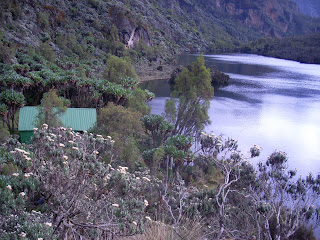
Eventually, there is the Elena Hut. We took 45 minutes there and continued on our way down. Our night's resting place was the Kitandara Huts, on the shore of the lakes of the same name.
For a place with such a fierce rep for rain, we have seen a tremendous amount of good weather. Not southern California good weather. More like Glacier Bay, Alaska good weather. Still, good enough weather to consider doing some rock climbing here.
The west wall of Mt. Baker is no slope you would ever think you could walk up. It is closer to a big wall, than it is to a crag. There may be a route where you would be scrambling after 600' of steep rock climbing, but not many.
Vittorio really had me going, when, in an 'aha!' moment, I asked, wide eyed, if the waterfalls we were surrounded by ever froze? A thousand foot waterfall is ordinary here. There are plenty of bigger ones. Imagine ice routes on the Equator! I found out later, from the boss of the Ruwenzori Mountaineering Services, that, no, they don't freeze. Just atmospheric ice- rime ice. I'm not going to fly 18 hours for patches of rime.
But I could be encouraged to throw in a pretty good rack for a climb on the W. face of Baker. And a traverse of Speke. And a long ridge traverse of Margherita and Alexander.
So, you Ruwenzori vets out there, (I know there are none- nobody goes to the R. and, then, nobody reads this. The odds would be astronomical. I can tell all the lies I want.) I hope I may be excused for considering rock climbs on the large West Face of Mount Baker. I can only imagine what it would be like in rain. The gear list would require wetsuits and a chisel and hooks. There would be plenty of features routes would follow where a guy could drown. The slabs on the southern end of the wall, towards the lakes, would be pretty tough in the wet. On the northern end of the 2mile(?) long wall is steeper terrain, better suited to climbing in the rain.
However, I really like the idea of coming home to a hut after a day on the crags. Considering how wet everything would get in a tent, after a week in a wet basecamp. Maybe the next trip should include a clothes dryer, one of those salad shooter style rigs.
Needless to say, my time between The Elena Hut and the Kitandara Huts passed very pleasantly, considering the tactics needed to climb the routes I saw before me made for pleasant amusement.
The hut is spectacularly situated well within view of the lake, right off the front porch. The lakes are beautiful, yet still at 13-some thousand feet. Again, every day is a bell ringer.
Tuesday, March 2, 2010
Subscribe to:
Post Comments (Atom)


No comments:
Post a Comment